User Systems: HRIT/EMWIN Overview

The Emergency Managers Weather Information Network (EMWIN) is a direct service that provides users with weather forecasts, warnings, graphics, and other information directly from the National Weather Service (NWS) near-real-time. The GOES EMWIN relay service is one of a suite of methods to obtain these data and display the products on the user’s personal computer. The HRIT (High Rate Information Transmission) service provides broadcast of low-resolution GOES satellite imagery data and selected products to remotely located user HRIT terminals.
The GOES-R Series continues the previous broadcast services of LRIT (Low Rate Information Transmission) and EMWIN but does so at a significantly higher data capacity. This was accomplished by combining the two services into a single service with a data relay capacity of 400Kbps. This compares with the previous LRIT service at 128 Kbps and EMWIN that transmits at 9.6 kbps on the GOES I-M (8-12) series and 19.2 kbps for the GOES-NOP (13-15) series. The new service is called HRIT/EMWIN—HRIT for High Rate Information Transmission.
The HRIT service requires users to acquire new receiver hardware as well as a receiver frequency shift to 1694.1 MHz, from 1692.7 MHz (EMWIN) and 1691.0 (LRIT). With encouragement from NWS (operator of the EMWIN Program) and NESDIS (operator of the current GOES LRIT service) the GOES-R program undertook a technology demonstration program to show that relatively inexpensive receivers designed for the new service:
- Supports not only HRIT/EMWIN but all of the predecessor services, eliminating costly and disruptive changes to the user systems as the services evolve from the GOES-I-M era, to the GOES-NOP series, and finally to the GOES-R Series.
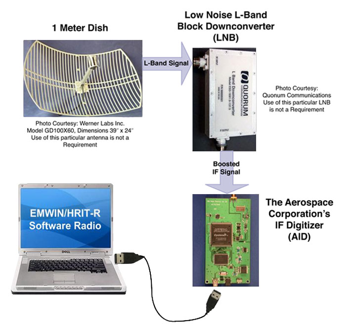
- Through the technology of Software Defined Radio, the receiver consists of a modest amount of hardware (an antenna, low noise amplifier and a computer interface) at very low cost. The bulk of the traditional signal processing, error correction decoding and data recovery and display can be done in a convention personal computer.
- Has a design that is available to all users, hobbyist and manufacturers, with the software available to anyone at no cost.
For more additional documentation about HRIT/EMWIN, please visit the receiver links section.
Additional information about current operational LRIT and EMWIN services can be found via NOAA websites.